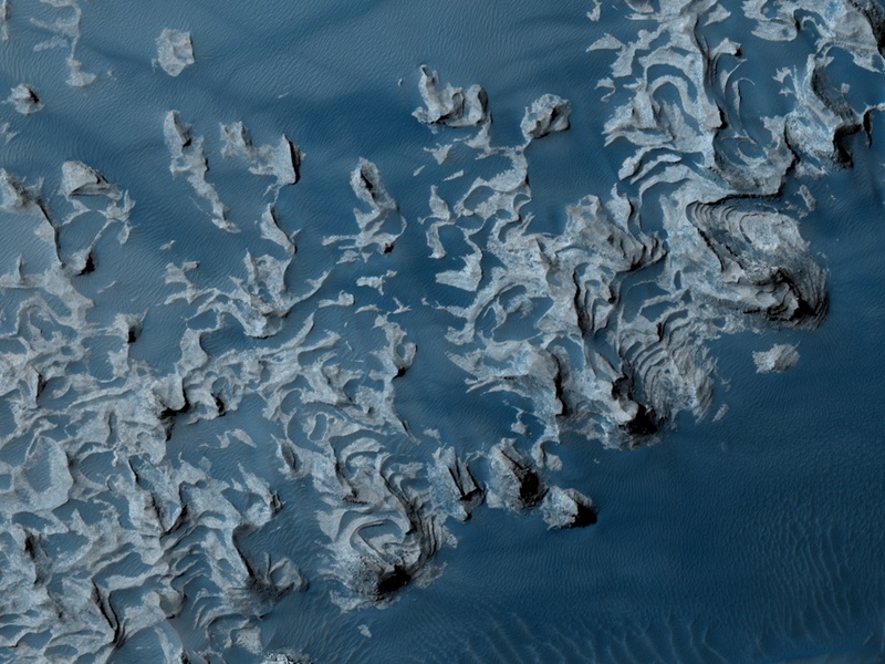
첫 눈에 보기에 파란색의 파동모양을 한 이 사진은 마치 바다의 파도를 보는 것과 같다.
사진에 보이는 것은 화성탐사궤도위성(MRO, Mars Reconnaissance Orbiter)이 고해상도 과학실험용 카메라(HiRISE camera)로 촬영한 사진에 인공적인 착색을 가한 것으로 이들은 실제로 화성의 Aureum Chaos에서 발견된 퇴적돌출부를 촬영한 것이다.
이곳 Aureum Chaos 지역은 화성의 거대 협곡인 마리너 협곡의 동쪽지역으로 어지럽게 헝크러져 있는 침식지대이다.
이처럼 퇴적돌출부가 형성된 이유는 대기상에 날리는 화산재나 먼지가 쌓인 것일 수도 있고 화성의 바람으로 인해 모래가 운반되면서 생긴 것을 수도 있으며 옛날 원래는 호수였던 이곳 바닥에 침전물이 쌓이면서 생긴 것일 수도 있다.
이 사진에 일부가 찍힌 Aureum Chaos 지역은 걸어서 한시간도 채 걸리지 않는 약 4킬로미터에 걸쳐 뻗어 있다.
정보출처 : NASA- 오늘의 천체사진(2008년 4월 4일 자)
http://antwrp.gsfc.nasa.gov/apod/astropix.html
참고 : 다양한 화성의 풍경 등, 화성에 대한 각종 포스팅은 아래 링크를 통해 조회할 수 있습니다.
https://big-crunch.tistory.com/12346937
원문>
Layers in Aureum Chaos
Credit
,
,
,
Explanation: At first glance these undulating shapes in shades of blue might look like waves on an ocean. Seen here in a false-color image from the Mars Reconnaissance Orbiter's HiRISE camera, they are actually layered rock outcrops found in Aureum Chaos. The larger Aureum Chaos region is a chaotic jumble of eroded terrain in the eastern part of Mars' immense canyon Valles Marineris. Distinct layers composing these outcrops could have been laid down by dust or volcanic ash settling from the atmosphere, sand carried by martian winds, or sediments deposited on the floor of an ancient lake. This close-up view of the otherwise red planet spans about 4 kilometers, a distance you might walk over flat ground in less than an hour.
'3. 천문뉴스 > NASA 오늘의 천체사진' 카테고리의 다른 글
| 해바라기 은하 (0) | 2008.04.17 |
|---|---|
| 화성의 위성 포보스 (0) | 2008.04.16 |
| NGC 7293 (0) | 2008.04.14 |
| 가스다발에 둘러싸인 말머리 성운 (0) | 2008.04.12 |
| 유리 가가린의 지구 (0) | 2008.04.12 |